Yosemite, Sequoia & Kings Canyon
- marinaundocked
- Jun 9, 2025
- 13 min read
7 days Exploring Yosemite National Park, Sequoia National Park & Kings Canyon National Park

Back at it again, tackling national park 14, 15 and 16 on my quest to hit all 63 parks by 63!
Day 1 - Flying to California
When trying to get to Yosemite there is no quick easy way to get there. You will definitely need to fly in and drive some distance
San Fransico - Yosemite ~3 hours to the park entrance
Sacramento Airport ~2 hour & 45 minute to the park entrance
Fresno Airport ~1 hour & 20 minutes to the park entrance
Los Angelos Airport ~5 hours to the park entrance
Las Vegas Airport ~ 5.5 hours to the park entrance
That being said Fresno Airport made the most sense to fly into as its also known as the Fresno - Yosemite Airport. We were getting the band back together from Glacier and added some new people to join in on the fun! Since we all flew in from all over the country after work (it was a Wednesday after all) it was a late first day. A few of arrived early so first stop was the grocery store to stock up on necessities since we were staying in the park and the closest grocery store was going to be at least an hour and half away. Scooping the second round of crew and waiting for our last personnel we had some time so why not hit In-&-Out at 1230 pacific time hahah! Due to delays and all we got to Yosemite National Park Airbnb around ~2:30 am PST after starting on the east coast. We were too exhausted to appreciate the place but decided to pass out and enjoy her early the next morning! Modern 3BR | Balcony | W/D - Houses for Rent in Yosemite National Park, California, United States - Airbnb It was a cabin within the actual National Park which was going to make it much easier for us to get around to exploring!
Day 2 - Yosemite National Park
After getting our bearings and lots of coffee we were packed up for the day and out the door. Our cabin was about 30 minutes from Yosemite Valley making it a quick drive in. Typically you see all these videos and photos of entering into Yosemite Valley through Tunnel view but none of those do it justice. Driving through the tunnel only for it to open wide to numerous waterfalls and large granite fixtures shooting into the sky will catch your breathe. This pull off was pretty packed, so we decided to come here later for sunset. There are various small pull offs to see views of the meadows, Bridalveil Falls, Yosemite Falls as you continue heading into the valley. Of course, we had to make a pit stop to catch the famous El Captain in all her glory! Our final destination was Campy Curry to find a parking and get ready to hike the Mist Trail.


Once in the valley and you are parked, I DO NOT recommend moving your car. You are better of getting on the shuttles to get around the park to various trail heads. Be prepared though for lines and crowds. Thankfully we were a short distance from stops 14/19. And found that honestly this was one of the best places to find parking!

From there we took the shuttle to 16 Happy Isles which would lead us to the Mist Trail. https://www.alltrails.com/trail/us/california/sentinel-meadow-cooks-meadow-loop-trail There are multiple turn around points along this trail depending on your skill level. First stop oh the hike was a footbridge which has a view of Vernal Falls and ~ 1.6 RT, note there is a steep climb to start this trail.

Continuing up the trail from there you can eventually split onto the John Muir Trail towards Vernal Falls & then Nevada Falls, or you can take the Mist Trail towards the top of Vernal Falls. We of course opted for the Mist. But don't let the name fool you. Between spring in the valley, the falls were roaring loud and hard and we were soaked before we could even get halfway up. I recommend packing a poncho or a change of shirt or something.

Since we did not pack accordingly, we were charging towards the top and didn't get to soak up the above view for long. We had a variety of skill levels on this hike, but all were able to make this climb, and we did see various small kids with parents making the climb. Once at the top there is quite an area to sit in the sun, enjoy the views and even get extremely close to the edge of Vernal Falls. To the top of Vernal falls would be roughly 2.4 miles RT if this was your last stop. We sat for a bit, attempted to dry off some in the sun and enjoyed our snacks we packed.


From here we continued on the 0.1 mile to reach the Emerald Pools and began our ascent to Nevada Falls. It does get steeper from here and we reached the next foot bridge not too long after. From here you can take a distant view of Nevada Falls. The hike to the Top of Nevada falls is roughly 5.4 miles RT. We wanted to make it to the top of Nevada which also has a bridge but between not packing our sandwiches and some personnel that were tired we opted to head back down the John Muir Trail to get back to our car. You can take the Mist Trail also back down but be prepared as it is extremely slippery on the stone steps heading down. If you have a walking stick this is a great time to use them. Overall, our hike was roughly a little over 4.3 miles RT.


Once back at the car we enjoyed our sandwiches we packed and few snacks. Camp Curry has various picnic tables and places to stop into if you don't pack a lunch. They have a food hall, gear store, coffee shop and places to rent bikes as there is a hotel/campground here. After our very late lunch we decided to hop on the shuttle and head to Lower Yosemite Falls (Stop 6 on the shuttle). This hike is a short 1.2 mile hike, mostly paved and a wheelchair friendly side! It takes you right to the bottom of Yosemite Falls with killer views. Lower Yosemite Falls Trail, California - 16,428 Reviews, Map | AllTrails. While we saw this in the afternoon the sun had disappeared, but this would be a great stop early morning/afternoon. From here you can also do upper Yosemite falls but that is more of a difficult hike depending on your skill level.


Getting late into the afternoon we took the shuttle back to our car to stop back at Tunnel View for sunset. We got there a little later than we wanted but the views did not disappoint. I definitely preferred this area at sunset over sunrise for photos. Back at our cabin after we cooked out and had some drinks while we discussed our plan of attack for the next day.


Day 3 Yosemite National Park
Day 3 started a little slow as we enjoyed the wildlife around us at the cabin. Once we were out the door we decided to explore the Glacier Point part of the park. This was roughly 30 minutes from our cabin. This is heading up the mountain, so it definitely was a little cooler up there than the valley. Our first hike of the day was Sentinel Dome, a roughly 2.75 mile RT if you indeed go all the way on top of Sentinel Dome (which I HIGHLY recommend). Sentinel Dome Trail, California - 3,540 Reviews, Map | AllTrails The trail parking is very limited so make sure to get there early! The hike starts through various trees and some relatively flat grounds as you make your way towards the valley drop off. Eventually it opens up to relatively flat rocks to climb up and finally you reach the base of Sentinel Dome. This was roughly a 2 mile RT hike if you stop here. But that was just short of the best views. Heading up the right side of Sentinel you start to see peaks of the infamous half dome and Yosemite Falls below. About another half mile puts you at the base of the climb of Sentinel Dome.


From here there are endless views of all different sides of the valley. This includes Nevada Falls, Vernal Falls, Half Dome, Mirror Lake, El Captain and Yosemite Falls. We soaked in the view as there were minimal people on the trail. Making it this far it was not a question we were going to hike up the side of Sentinel to get the true view. There was some snow left here but most thankfully had melted away. So, if you are visiting other times of the year keep that in mind when in Glacier point. Once at the top the views will take your breath away.

We spent some time up here just sitting, listening to the wildlife, using the binoculars to see what we can find and take in the true 360-degree view of Yosemite. Of course, can't forget my go to snack Twizzlers [please sponsor me :)]


After we decided to head back into Yosemite Valley to explore some more. This is roughly 40 minutes from Sentinel Dome trail head. Again, we parked at Camp Curry had our lunch and this time stopped for a coffee as we were all struggling with the time change. With Memorial Day weekend coming we opted to finish all activities in the valley by the Friday to avoid the crazy crowds that were coming that weekend. If you are planning on doing multiple days in the park it always pays to get the America the Beautiful Pass, this is the annual pass that gets you into all the parks. Entrance Passes (U.S. National Park Service) Note if you plan to enter Yosemite National Park between 6 a.m. and 2 p.m. on Memorial Day weekend, any day between June 15 and August 15, or Labor Day weekend will need a reservation. Yosemite National Park Ticketed Entry - Recreation.gov this is due to Yosemite being one of the most visited National Parks in the country! They do indeed check these and will turn you around if you do not have one.

Coffee in hand, next stop was Crook Meadows and walking through the Valley. Cook's Meadow Trail, California - 455 Reviews, Map | AllTrails This is about a 2-mile RT hike with views in every direction. We walked the trail and swung over to Sentinel Bridge which offered a stunning view of half dome from the river. This was also a great spot to rent the bikes and ride through the park in. Following this we stopped by the Valley Museum, the Visitor Center and Post Office all known as Yosemite Village (Shuttle stop 5).


Hoping on the shuttle from here we headed south to check out Bridalveil Falls. Bridalveil Fall Trail - Yosemite National Park (U.S. National Park Service) This is a short 0.8-mile RT hike. Like Vernal Falls the spring magic had this fall roaring and we did get a bit soaked when posing at the base. This trail head continues on over some bridges for a longer hike and will drop you back into Crook Meadows if wanted. The best views are mid to late afternoon when the sun hits it like below!

Our last planned hike was Artist Point a 2.3 Mile RT hike which starts at the Tunnel View Parking Lot. Artist Point Trail, California - 1,499 Reviews, Map | AllTrails Unfortunately, by the time we got back to our car on the shuttle and then to the trail head it was a bit late in the day. So, we decided to soak up the golden hour magic of tunnel view one last time before heading back to the cabin for dinner and packing. These views did not disappoint.


Other Yosemite hikes we wanted to complete but ran out of time was Tenaya Lake and drive Tioga road. This is a stunning part of the park but sadly Tioga road was not reopening until Monday after we would be gone. A second spot was Hetch Hetchy a part of Yosemite only 1% of people actually visit as it is a bit of a hike from the rest of the park. Here you can hike to Wapama Falls which is roughly 5 miles RT.
Mirror Lake - 5 miles RT
Four Mile Trail - 5 miles RT
Clouds Rest - 12.4 miles RT
Elizabeth Lake Trail - 7 miles RT
Thousand Island Lake - 14.3 miles RT
Day 4 - Yosemite & Sequoia National Park
For our last day in Yosemite we decided to do sunrise at Glacier Point. Glacier Point Trail, California - 3,103 Reviews, Map | AllTrails This was one location where sunrise and sunset both would be beautiful. This parking lot is small and does get filled up fast. We arrive about 30 minutes before sunrise and it was half full. We took the winding road up to glacier point where you swing through the horseshoe switch back with the breath taking half dome shot seen below.

The trail head is roughly 1 mile RT give or take. There is various vantage points here including a geology hut. We opted to take the geology hot and wait for the sunrise. Even in the dark you could see the glow of Vernal & Nevada Falls all over Half Dome. You can even spot venus below in the photo upon our arrival. This was my favorite viewpoint of the trip, the stars the falls, half dome and being able to spotlights from the hikers at the top was a view that photos don't even do it justice. After this it was time to pack up and head back to the cabin to head south to Sequoia!


On the way south to Sequoia which is relatively a 2.5 hour drive we opted to break up the trip with a few stopping points. Heading south out of Yosemite there is Mariposa Grove. Note you have to park at the visitor center and take the shuttle bus to the grove. They do not allow outside vehicles to the top. Mariposa Grove of Giant Sequoias Trail, California - 3,176 Reviews, Map | AllTrails Here you can get out and complete a 2-mile RT hike through various sequoia trees in Yosemite! The round-trip hike has views of the Fallen Monarch Tree, Bachelor tree & the three graces, Grizzly Giant and California Tunnel Tree. The trail continues on, or you can loop back to the start. It was a good halfway point to Sequoia to get out and stretch our legs. The photos rellay don't do the tree justice on their size.


Following this we stopped in Oakhurst to grab a quick lunch at Smokehouse 41 a very famous BBQ joint. This place has killer food! It does get extremely packed so be prepared to wait in a line, but it is well worth it. The portions are huge so don't be afraid to share plates. SmokeHouse41.com - Barbeque Restaurant, Bbq, American Restaurant
Once in Three Rivers we checked into our Airbnb, this is the town right outside of Sequoia National Park and is also known as the Gateway to Sequoia. Green House - newly updated! - Houses for Rent in Three Rivers, California, United States - Airbnb Since it was late afternoon, we decided to stop into the visitor center for the famous sign picture and view tunnel rock, which is a walk-up photo op, where the main road use to ride through.


From here we decided for one last short hike/walk up to Hospital Rock which still has visible petroglyphs. To the right of a rock is a short trail to the river and small waterfall all within 0.3 miles RT. Hospital Rock River Trailhead (U.S. National Park Service) This concluded our very long day 4!


Day 5 - Sequoia National Park
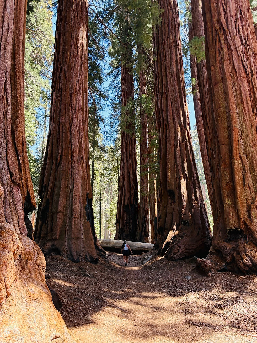
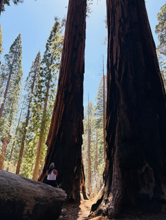
This being the Sunday of Memorial Day weekend we were up and at it early to avoid the crowds (Joke was on us haha). Parking is extremely limited in this park, and this is typically their busiest day of the year. In hindsight we probably should have switch our Day 6 and 5 Itinerary's to avoid the masses, but it worked out okay. Sequoia Park is vary deceiving as you start the bottom in the valley and almost dessert like area before taking a long drive with numerous switchbacks to the top, here the massive Giant Forest Sequoia Grove. Here the trees open up and take over as far as eyes can see. Sadly, back in 2022 they had some massive wildfires that shut the park down and burned ~20% of the trees in the park, you can still see the devastation of the fire. But the thing you learn about the sequoia trees from walking around and reading the various signs is that they actually require the fires to grow and sustain life in the park.

We parked at Wolverton parking lot as the giant tree lot was full. The shuttle line was extremely long, so we opted to hike the ~2-mile hike (Lodgepole-to-Sherman Tree Trail) down to Sherman Tree Main parking lot/trail head. This was a very pretty and easy hike, and we were very glad we opted to take this instead. The train head dead ends at the General Sherman Tree trail head. This is a paved very easy and kid friendly hike through various large sequoias.

Continuing on we then connected to Congress Trail a roughly 2.9-mile loop mostly paved to see various large famous sequoias. This includes but not limited to "The House", "The Senate", Presidents Tree. Congress Trail, California - 5,047 Reviews, Map | AllTrails


Next, we took the shuttle bus down to Forest Museum Area. Here you can stop in the Giant Forest Museum. Here you can find Sentinel Tree. Also here starts the trailhead for Big Trees Loop, a nice 1.3-mile RT hike through the low meadow and various Sequoias. Big Trees Trail, California - 2,439 Reviews, Map | AllTrailsTheres also a metal tablet which explains how the private owners bought the land of the great sequoia grove and deeded it to the United States in 1916 for the people. Thus, Sequoia National Park was born!


Other great hikes we wanted to complete but ran out of time were:
Tokopah Falls - 3.4 Miles RT
Marble Falls Trail - 6.3 Miles RT
Pear Lake - 11.9 miles RT
Precipice Lake - 38mile RT (permit required)
Day 6 - Kings Canyon National Park
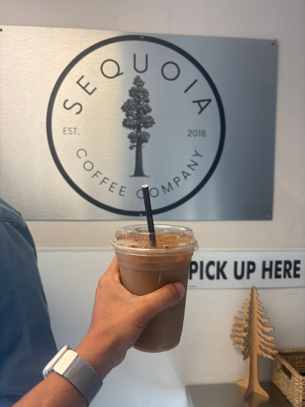
For our last full day, we were spending it in Kings Canyon. This park is actually split in two by a national forest but is located just north of Sequoia. First stop of course was Sequoia Coffee Company, a cute coffee shop found in the heart of Three Rivers.
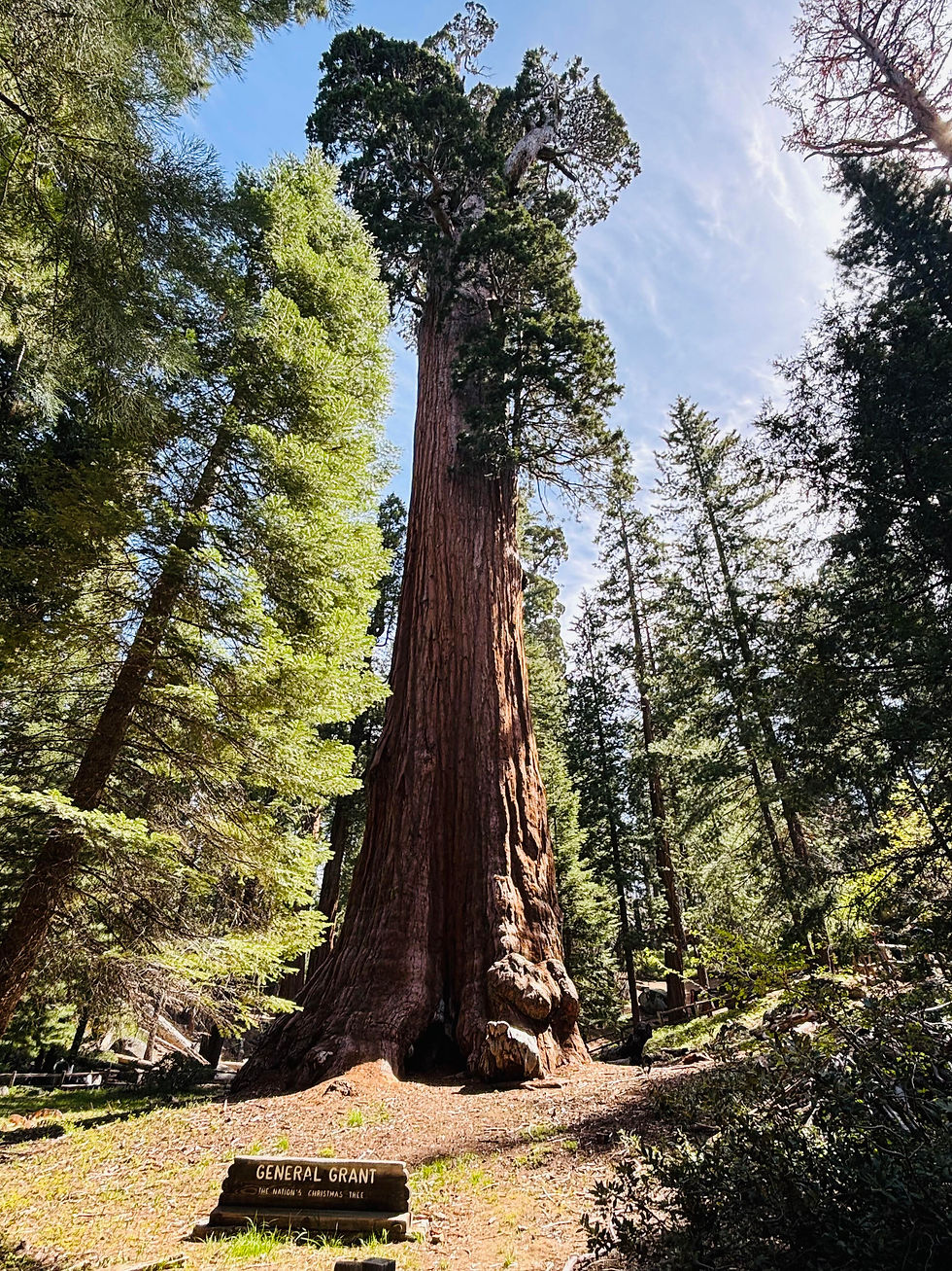
We opted to drive around the outside of Sequoia to get to Kings Canyon. the first part of the park is located on the Northwest side of Sequoia. Here our first stop was the Grant Tree Trail. This grove has been known to be some of the best sequoia habitat. This hike was a sort 0.5 mile hike all paved but provided an extreme close up to some of the largest sequoias we saw on our trip! General Grant Trail, California - 4,097 Reviews, Map | AllTrails In this grove there is various sequoia trees that have fallen and even one you can climb and walk all the way through. At the midpoint and the center of the grove is the Sequoia known as General Grant.


From here you drive further through the National Forest before arriving to the other side of Kings Canyon which is located on the Northeast side of Sequoia NP. One spot we wanted to stop for but didn't have time was the Boyden Caverns, here you can take a 50-minute guided tour which features stalactites, stalagmites, flowstone, pendants, and shields. Tickets are limited for certain slot periods.

All the way at the end of the park was our first hike Zumwalt meadows. Zumwalt Meadow, California - 1,212 Reviews, Map | AllTrails This 1.5 mile RT hike was great for wildlife and had us climbing over some larger boulders. Along the bank is where we opted to have lunch.


Heading back towards the front of the stop we did make detours for various walk up viewpoints, including Roaring River Falls and Grizzly Falls. Both were less than 0.2 miles. Roaring River Falls, California - 791 Reviews, Map | AllTrails & Grizzly Falls, California - 355 Reviews, Map | AllTrails. This park also had numerous other hikes if we had more time we wanted to complete but were also rated more strenuous.


Buck Rock Lookout - 4.8 Miles
The Heart Tree & Fallen Goliath Loop - 7.2 miles
Once back through Kings Canyon we decided to take the scenic drive through Sequoia back to our cabin as we concluded our trip!

Day 7 - Travel
Sadly, it was time to head home... until next time!


Comments