Glacier National Park - Montana
- Marina Undocked

- Sep 12, 2022
- 14 min read
Updated: Jul 9, 2023
National Park 10 of 63... of the goal of 63 parks by 63!

Back in high school I took a trip out west to Montana. We flew into Helena and head out into the back woods as we spent a few days canoeing 40 miles, hiking and camping along the Missouri River, just like Lewis & Clark did... After that trip, Montana has always been my favorite state to visit. A few months back I received a text one morning at work from some family friends saying, "How about Glacier National Park for five days at Labor Day weekend?" Now if you know me, this was the best kind of text I could receive. So, there we were beginning to plan 5 days in Montana and 3 full days in Glacier National Park. Follow along below, for our itinerary and all the ins and outs you need for planning your trip to Glacier! Each of the Below Sections can be clicked on to quickly jump to what you are looking for!
Where to Fly Into
When you are trying to get to Glacier National Park, depending which direction you are coming from there is a few flight options. There are multiple smaller airports but for larger main Airports options there is Billings (BIL), Bozeman (BZN), Great Falls (GTF), Missoula (MSO) or Kalispell (FCA). Which airport you choose to fly into will obviously make a difference in your drive time to the park as well as overall cost of the fight. Approximate times from each airport to the entrance of the park in West Glacier are as follows:
Billings (BIL): ~6.5 hour drive
Bozeman (BZN): ~5 hour drive
Great Falls (GTF): ~ 3 hour drive
Missoula (MSO): ~2.25 hour drive
Kalispell (FCA): ~ 1 hour drive
Due to costs and flight options into Montana from Florida we opted to fly into Missoula, which allowed us to make a pit stop at the National Bison Range on the way into town.
National Bison Range
About halfway on our drive to White Fish (where our cabin was) we decided to take a drive through the National Bison Range. This is located at 58355 Bison Range Rd, Charlo, MT 59824. This range allows to drive the preserved land and has two small hiking trails you can even take. Starting at the visitor center, you drive west along the gravel path up into the hills where it loops around back through prairie drive to the visitor center. Depending how often you stop along the way the entire loop is about 2 hours or so.

This scenic drive takes you through out multiple landscapes overlooking a valley where you will be able to see multiple deer, bison and other wildlife. Reminder, although you are on a range the wildlife is WILD; so, make sure to stay in your car or if on one of the hiking trails keep your distance. This drive did not disappoint, and it was interesting to learn that the valley below was home to what was once the Glacial Lake Missoula. Approximately 15,000 years ago the valley below the mountains was flooded creating the glacial lake, which even had multiple icebergs flowing through it.


Whitefish, Montana
After our drive we hit the ground running toward Whitefish, the cute little town in which we had rented a cabin to stay in for the week. We wanted to find our cabin first before it got dark which was usually around 830 or so, to drop our things off before heading back into town for dinner. Along our drive into Whitefish, you pass along the famous Flathead Lake. This lake is actually a remnant of the Glacial Lake Missoula (which we had just learned about at the Bison Range). The lake now a days covers approximately 197 square miles, and its deepest point is approximately 370 ft deep. The lake is surrounded by various Marinas, Cabins and Cherry Orchards. This is also a great town to stay in because of the historic downtown and lake which offers such a variety of activities.
Finally, we arrived at Whitefish in the late afternoon. Our cabin was approximately 15 minutes from the historic downtown district. White Fish was definitely one of the larger towns in the local area and with its ~30/45-minute distance to the entrance of the park in West Glacier it was easy to see why.

Places to Stay
The Lodge at Whitefish
Hidden Moose Lodge
Grouse Mountain Lodge
Good Medicine Lodge
The Firebrand Hotel
Best Western Rocky Mountains
Chalet Inn
TownePlace Suites
Baymont by Wyndham
Hampton Inn Suites
Cabin Rentals - VRBO, AirBnB, Stump Town Vacation Rentals
Places to Eat
The Buffalo Cafe - Lunch & Dinner
Jersey Boys Pizzeria - Lunch & Dinner
Piggyback BBQ - Lunch & Dinner
The Wich Haus - Lunch & Dinner
Loula's Cafe - Breakfast & Lunch
Swift Creek Cafe - Breakfast & Lunch
Abruzzo Italian Kitchen - Nicer Italian Dinner
Great Northern Bar & Grill - Lunch & Dinner
Latitude 48 Bistro - Dinner
Mama Blancas - Mexican Food
Sweet Peaks - Ice-cream Shop
Fleur Bake Shop - Bake goods & Coffee
Montana Coffee Traders - Coffee
Crema - Coffee Drive Through
Also, all over Montana, there was multiple small drive through Espresso/Coffee shops.
Make sure to swing by one when you get a chance.


Glacier National Park

Park History
Glacier NP is a breath-taking park with over 700 miles of trails covering a mixture of melting glaciers, carved valleys, alpine meadows, parries, and beautiful lakes. This park is found within Montana's Rocky Mountains bordering the Candian border. Originally home to the Blackfoot, Flathead and other Indians tribes. Later Lewis & Clark would actually come within 50 miles of what is now the national park. The park was founded in 1885 by George Grinnell and with the help of his buddy, President Taft, the wilderness became an established national park in May of 1910. The park is often referred to as the "Crown of the Continent". Upon exploring the National Park, there is no question into why all refer to this region as such. Today's park can be split into the following sections: Nork Folk Area, Goat Haunt Area, Many Glacier Area, Lake McDonald Area, St Mary's Cut Bank Area, Walton Area and Two Medicine Area (Refer to the Map Below).

Entry Requirements
The requirements to enter the park, vary based on the time of the year you are planning to visit. To travel from West Glacier to East Glacier, the Going to the Sun Road is the only way through the park to get from one side to the other. This park is considered more of a seasonal park, where their peak season is typically June to Mid-September. Visiting in the winter is still allowed but numerous sections of the park are either shut down or in accessible due to snow. You will first need a National Park Pass. The annual Glacier pass is $70 and can be purchased online ahead of time or at any of the visitor centers. This will cover yourself and anyone in the car under this pass. Second if you choose to visit between May 27th and September 11th the park sets up a vehicle reservation pass to cut down on the number of cars and crowdedness in certain parts of the park. The two main roads, going to the Sun and North Folk Region require this pass. The pass is valid for three consecutive days and opens 8 am MT the day prior to travel. This park allows travel on these roads 6am to 4pm. Note the Going to the Sun Road didn't fully open until July 13th this year. All questions regarding the pass can be found at the following site.
Don't worry, if you do not manage to get this pass, you can either enter the park prior to 6am and after 4pm. Or enter into West Glacier and take the shuttle throughout the park.

Day 1
With only three full days in the park, we did not waste time in the parks arriving early each day just before sunrise. For Day 1 we decide to make the drive from West Glacier to East Glacier along Going to the Sun Road and to stop along the trails and pull outs as we wanted. Note if you are going from West to East Glacier via this road it typically will take 1.5 - 2 hours without stopping. First stopping in the Apgar Visitor Center for additional maps and to check on if there were trail closures. We hit the road and after driving some time, we decided to catch sunrise on Lake Mcdonald.
Lake Mcdonald

This is one of the most known parts of Glacier National Park. The various minerals from the glacier and sediments formed rocks of all different colors when wet. This lake holds not only the Lake McDonald lodge but also various trails around the entire lake. This lake is fed from the creek that flows throughout Glacier NP with McDonald Falls on the north side. There are various pull-off designated sections on the Going to the Sun Road, to allow people to park and walk down to the lake. See below for major hikes surrounding the visitor center and Lake McDonald. Of this region, Apgar Lookout (Fire Tower), Avalanche Lake and the West side trail of the lake were some of our most desired to hit. Sadly, due to time we were only able to hit Avalanche Lake later in the week.


McDonald Falls
After sunrise, we continued along the road stopping at McDonald Falls. This is found on the North Side of the Lake and is feed from the creek. There is mainly a small sidewalk section of the pull out to capture the falls from afar. But of course, Alex and I had to attempt for a better closer look, following a well designated area next to the pull out as shown below.


Heaven's Peak & The Loop
Next stops within the park were Heaven's Peak seen below and making the sharp turn in the road known as "The Loop" which sends you north and up into the mountains towards Logan's Pass. This part of the road officially enters you into Logan Pass and the St Mary region. Click below for a map and layout of the trails.


Logan Pass

Logan Pass is found at the center of the park and the center of the Going to the Sun Road. This spot is known as the continental divide and has an elevation of 6646 ft! Making this one of the more popular stops along the road, in which the parking spots fill up fast and extremely early. Hidden Lake Trail (~ 3 - 4.5 miles RT) and the Highline Trail (~12 miles RT) are the most popular trailhead found here. We had no luck securing a spot on Day 1 so about 20 minutes later we decide to continue up the road and try to get into St Mary Falls.

St Mary Falls, Virgina Falls
Thankfully, at this trail head there was plenty of parking at the time of our arrival, so we decided to warm up our legs here. Here is where we noticed various trail maps and signs on site differed from each other (usually only different by .25 miles or less), but it was approximately 1 mile from the trail head to St Mary Falls and then another .5 miles to reach Virginia Falls. In this part of the valley, it was clear to see the damage from the wildfires in previous years. But it was also obvious that there was life coming back to the region which was great to see. The whole trail was covered with various flowers and trees making their comeback. At the start of the trail, one of the other hikers told us, we had just missed a moose down on the lake by 2 minutes (that hit hard but we did see many chipmunks, snakes, pikas and squirrels along the trailhead. First was St Mary Falls which had two waterfalls and was gorgeous. This can be seen below. We spent some time here and had some of the snacks we packed for the day. After a while we decided to continue on the last half mile to Virgina Falls before head back the 1.6 miles to the start of the trail head. Heading back to the trail head we decided to take advantage of the shuttle and use it to get back to Logan's Pass.


Hidden Lake Trail at Logan Pass
Sadly, due to a momma bear and her cubs the trail section from Hidden Lake Trail Overlook to the bottom of the Lake was shut down. But we were still able to hike the section into the mountains towards Hidden Lake. The trail to the overlook was approximately 1.5 miles one way. We saw all ages on this relatively marked trail. Reaching the end of the trail it was obviously why this is one of the more popular hikes of the park. There were gorgeous alpine valleys, mountains, melting ice, flowers and creeks found throughout the trail. After this hike it was getting quite late in the day, so we took the shuttle back to our car and finished the going to the sun road before turning around at St Mary's Lake and headed back to White Fish for dinner.


Day 2
For Day 2 we decide to take the Going to the Sun Road through to St Mary Lake and then into Many Glaciers Region. Note at the end of St Mary Lake you do exit the park, head north on the hide way before exiting west into the park again known as Many Glacier. This region is known for glacier overlooks, various lakes and plenty of wildlife especially early in the mornings.
St Mary Lake
Sunrise on St Mary Lake was unbelievable.

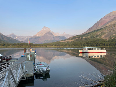
Many Glacier
Entering the Many Glacier region, the focal part is the Many Glacier Hotel. This hotel has a Swedish look to it based on the founders of this region referring to it as the American Swedish Alps. At the main parking lot of the hotel, you can find the various trailheads of this region. This parking lot is known to fill up completely by 8am, so of course we got their early. Trails in this region are very lengthy typically, making ti harded to find parking later in the day. From this parking lot there are various trailheads around the different lakes as well as horse trail tours you can take through out the day. Various known hikes of this region include but are not limited to: Cracker Lake, Iceberg Lake, Swiftcurrent Lake, Lake Josephine, Grinnell Lake, Grinnell Glacier, Swift Current Pass, Fisher Cap Lake, Red Rock Lake and Bulhead Lake. For the first hike we decided on making the 8-mile round trip hike up to the Grinnell Glacier Overlook and Upper Grinnell Lake. The region did not disappoint as we saw many bears, squirrels, chipmunks, goats, etc.
Cracker Lake: ~6.1 miles one way
Red Rock Falls: ~2 miles one way
Bullhead Lake: ~3.5 miles one way
Iceberg Lake: ~ 4.8 miles one way


Grinnell Glacier Overlook
There are various ways to get to not only Grinnell Glacier Lake but also Grinnell Glacier from the Many Glacier Hotel. First is to start the trailheads directly from the hotel around Swift current Lake, then passing Lake Josephine and onto Grinnell Lake.
Swift Current Lake Loop Trail ~2.6 miles
Many Glacier Hotel to Lake Josephine ~ 0.9 mile one way
Grinnell Lake (trail only) ~ 3.5 miles one way
Grinnell Glacier Overlook (trail only) ~5 miles one way
The second option is to take a mixture of the boat tour and trail heads. This was the option we decided on. The boat takes off about every hour from Many Glacier, and you can either make a reservation prior or try to get add on the wait list depending what time you arrive. This ride cost $17.50 one way or $35 round trip on the boats. The boat tour was going to save us an extra three miles give or take so we opted for it. The first boat takes you around Swiftcurrent lake as the captain will give you a breakdown of the history of the region and points out major peaks and items. This then hits a dock on the opposite side of the lake where you then take a 0.25-mile hike through the forest to Lake Josephine. Here you can take the second boat which will bring you across this lake and to the Grinnell Lake/Glacier Trailheads. Another option is to continue the trail from here around Lake Josephine towards the lake trail. Overall, this portion took about 45 minutes total. '


You never know what you might catch on the lake such as a dinosaur paddle boarding...


From here you take the trail head straight up to Grinnell Glacier Overlook. Note this is an extremely strenuous hike with an elevation raise of 3000 ft. But the views along the trail were breathtaking and makes you understand why they call it Big Sky Country. The parents didn't make it the full 4 miles up but got a majority of the way. So, we let them leisurely take their time down. Alex and I continued onward determined to get to the Glacier and Upper Grinnell Lake. The last mile was definitely difficult, but we made it to the top. People along the way kept saying it's worth it, keep going and man were they right (although we hated them at first haha). At the top Alex and I took some time to enjoy the views, eating our lunch and even dunking our feet into the Glacier Water (VERY COLD). Following this we decided to make the trek down to meet the parents back at the Lake Josephine boat pick up. Note the last boat ride is at 530pm but if you are there by then they take as many boat rides as needed to get people back. We definitely learned our lesson as we did not pack enough water for this trail. Thankfully at one point of the trail you pass through a waterfall of Glacier water in which we were able to fill up our bottles again like many others. I think we each drank about a gallon of water along on that hike. After reaching Lake Josephine again, we took the time to rest by the lake and hop in the water to cool off while we waited for the next boat ride home.


To end the day, we drove over to the Swiftcurrent Motor Inn to check out the Trailheads and parking situation for Day 3. We knew we wanted to make the ride back to this section of the park.

Day 3
Two Medicine
For Day 3 we decided to head back to Many Glacier Region again to try and catch more wildlife and hopefully catch a moose (our trip goal). Since Day 2 took a lot out of us, and we didn't have a Going to the Sun Road pass for this day we slept in and took the long way around to Many Glacier. This road took us on the southside of the park traveling through the Two Medicine Region, which was just as gorgeous. At this point we decided we definitely needed to come back and explore more of this region and the North Folk Region as well. Their trail maps can be found below.
Fishercap Lake, Red Rock Falls, Bullhead Lake
Parking at the Swiftcurrent Motor Inn early we were still able to snag a parking spot. Sadly, at the Inn the notice said the Iceberg Lake Trail was closed due to bears, so we opted for Red Rock Falls and Bullhead Lake trail. This is all one trail head which first takes you along the Fishercap Lake (~.5 miles in) and then forward to Red Rock Falls approximately 2 miles in. From here you can take the trail passing Red Rock Lake and onward to Bulhead Lake which is approximately 3.7 miles in. Again, sadly we missed the bear and moose sightings by just an hour according to other hikers... No luck on the wildlife for this day but the views were gorgeous. We had snacks along Bullhead Lake before taking the following 3.7 miles back to the car.


St Mary Lake & Going to the Sun Road
This took a majority of the morning, so we grabbed some lunch in St Mary before heading back into the park along the Going to the Sun Road. Again, stopping along the various overlooks. After our late lunch, we opted to head back towards Lake McDonald to explore the Trail of the Cedars & Avalanche Lake.


Trail of the Cedars & Avalanche Lake
There are two sections of Avalanche Lake in which you can park for the trail heads. Both take you through a portion of the trail of the cedars loop. This loop is a board walk trail that takes you through the various trees found in the region. Halfway along this trail you will reach the Avalanche Lake Trail head which is approximately 2 miles one way to the lake. This is one of the more popular trails in the Lake McDonalds region which had all ages from toddlers to elder adults along the trail. Upon reaching the lake the sun was starting to set on the valley. So, Alex and I decided to hop in the water to cool off and sit by the lake to enjoy the views before heading to catch the parents on the trail of the Cedars.


Lake McDonald
To end the trip, we watched the sunset on Lake Mcdonald on our way out of the park and back to Whitefish to catch dinner and head back to our cabin for drinks and packing.


Comments